Satellite and aerial maps of Den Helder Marinehaven (naval base) with nearby locations
| Nearby locations | Km | Bearing | |
|---|---|---|---|
| De Kooy , Noord-Holland | 4.0 | 189 | EHKD |
| Texel , Noord-Holland | 17.5 | 008 | EHTX |
| | 18.9 | 283 | |
| | 26.9 | 315 | |
| | 32.7 | 255 | EHQG |
| Vlieland Heliport , Friesland | 33.4 | 014 | EHVL |
Den Helder Marinehaven (naval base) |
| 52° 57' 34.19'' N 4° 47' 25.86'' E | ||
| 11mile N of Schagen, Den Helder, Noord-Holland |
For Den Helder airport see De Kooy
Den Helder Marinehaven (naval base) News |

CHC New Contract with Siemens Wind Power
17-Jan-17 - CHC to provide AW139 helicopter services from Den Helder, Netherlands to support Siemens Wind Power GmbH in construction of Veja Mate offshore wind farm in the German North Sea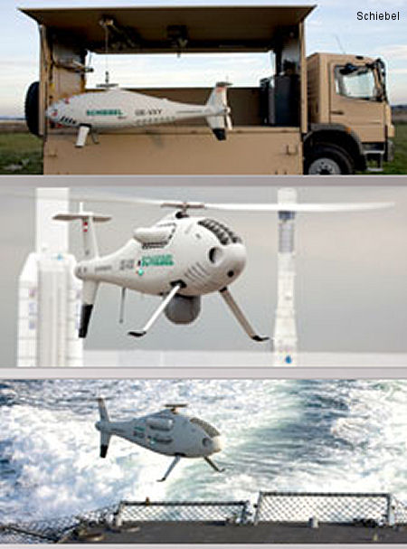
Camcopter S-100 maritime demo in Netherlands
30-Apr-14 - The Camcopter S-100 Unmanned Air System (UAS) successfully demonstrated its capability across several different maritime scenarios to Dutch Authorities in Den Helder, The Netherlands, on 29 April 2014. Operations at Den Helder Marinehaven (naval base) |
| Dates | Operation | |
|---|---|---|
| 04-jul-15 | 05-jul-15 | Marinedagen 2015 |
| 21-jun-86 | 22-jun-86 | Fleet days 1986 |
