Satellite and aerial maps of Wainfleet with nearby locations
| Nearby locations | Km | Bearing | |
|---|---|---|---|
| Seacroft , England | 9.3 | 040 | |
| RAMCO , England | 11.2 | 029 | GBSKE |
| Skegness , England | 13.8 | 023 | EGNI |
| | 16.4 | 057 | UK15 |
| | 18.5 | 246 | EGB12 |
| | 19.8 | 042 | UK11 |
Wainfleet |
1890 to 2010 | ||
| 53° 3' 30'' N 0° 14' 36'' E | ||
| Friskney, Boston, Lincolnshire, England | ||
| ICAO: EGYW | IATA: | |
| Elevation: 10 feet | ||
Originally created as a Royal Artillery range, it was opened for air operations in 1938.
After WWII, it became a NATO air weapons range run by the RAF. It was ideally situated beside mudflats with a shallow grading beach. It was extensively used by the RAF and RN and on 11/12 Mar 1999, it was the location of a bombing event which also raised money for the UK Red Nose day.
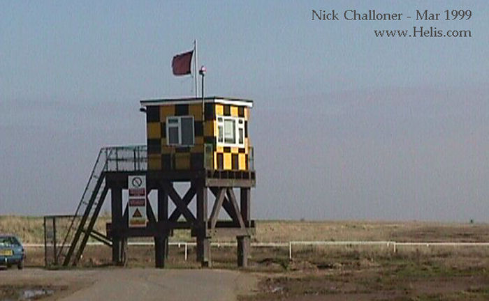
It was closed in 2009 and other UK ranges took up the strain. The Range Control Tower, observation posts (see picture), helipad (within Danger Area EG_D308 airspace) and other facilities were finally shut down in 2010.
Part of the range has been bought by a private owner; the Range Control Tower and its compound have been developed as holiday accommodation, with the installation of an RAF Jetstream T.1 and an Army Lynx AH.9. By Aug 2022, the Range Instrumentation / Safety Hut (shown above) has been demolished and removed while most of the roads have been blocked off to traffic but it is a popular site for dog walkers.
After WWII, it became a NATO air weapons range run by the RAF. It was ideally situated beside mudflats with a shallow grading beach. It was extensively used by the RAF and RN and on 11/12 Mar 1999, it was the location of a bombing event which also raised money for the UK Red Nose day.
It was closed in 2009 and other UK ranges took up the strain. The Range Control Tower, observation posts (see picture), helipad (within Danger Area EG_D308 airspace) and other facilities were finally shut down in 2010.
Part of the range has been bought by a private owner; the Range Control Tower and its compound have been developed as holiday accommodation, with the installation of an RAF Jetstream T.1 and an Army Lynx AH.9. By Aug 2022, the Range Instrumentation / Safety Hut (shown above) has been demolished and removed while most of the roads have been blocked off to traffic but it is a popular site for dog walkers.
List of aircraft and events at Wainfleet |
| Dates | Org/Type | Unit | |||||
|---|---|---|---|---|---|---|---|
| 2018 | Accommodation | AH9 | ZG914 | ||||
| 2022-aug-08 | AH9 | ZG914 | |||||
