Satellite and aerial maps of Hurn with nearby locations
Bournemouth Airport, Parley Green Lane, Hurn, Bournemouth, Christchurch and Poole, England, BH23 6BD, United Kingdom
1941 to present | | 50° 46' 48'' N 1° 50' 33'' W | | 3nm NNE of Bournemouth, Dorset, Bournemouth, Dorset, England | | ICAO: EGHH | IATA: BOH | | Elevation: 38 feet |
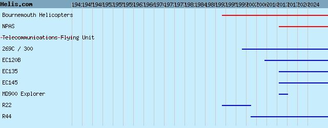
| Years | Unit | |
|---|
| 2014- | NPAS | EC135/H135, Camcopter S-100, MD900 Explorer, EC135, EC145, EC135, | | 1994- | Bournemouth Helicopters | EC120B, R44, 269C / 300, R22, | | 1941/?? | Telecommunications Flying Unit | |
|
|
Helicopters for sale
Accidents
Acronyms
Airshows
Future helicopters
Flying a helicopter
Helicopter stories
TV and movies
Helicopter books
Helicopter patches
Helicopter model kits

Download App
|