Satellite and aerial maps of Austin - Bergstrom AFB with nearby locations
Austin-Bergstrom International Airport, 3600, Presidential Boulevard, Austin, Travis County, Texas, 78719, United States
1943 to present | | 30° 11' 40.30'' N 97° 40' 11.61'' W | | 5nm SE of Downtown Austin, Austin, Texas | | ICAO: KAUS | IATA: AUS | FAA: AUS | | Elevation: 541 feet |
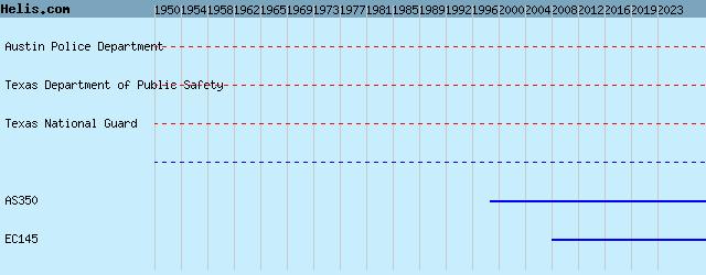
List of units at Austin - Bergstrom AFB |
|
|
Helicopters for sale
Accidents
Acronyms
Airshows
Future helicopters
Flying a helicopter
Helicopter stories
TV and movies
Helicopter books
Helicopter patches
Helicopter model kits

Download App
|