Satellite and aerial maps of Cheyenne with nearby locations
Cheyenne Regional Airport, Dell Range Boulevard, Cheyenne, Laramie County, Wyoming, 82003, United States
1937 to present | | 41° 9' 20.30'' N 104° 48' 37.69'' W | | 1nm N of Cheyenne, Cheyenne, Wyoming | | ICAO: KCYS | IATA: CYS | FAA: CYS | | Elevation: 6159 feet |
List of units at Cheyenne |
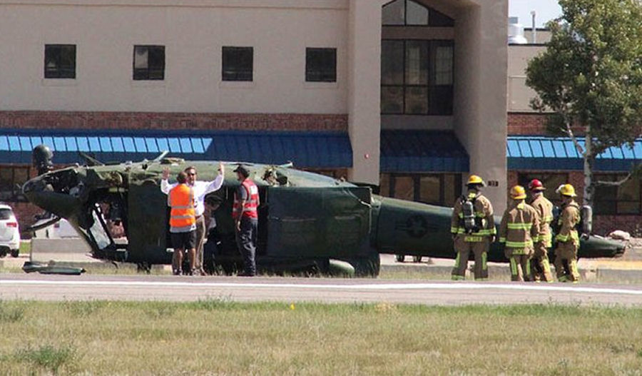
31-Aug-23 - An US Air Force Bell UH-1N helicopter assigned to the 37th Helicopter Squadron (37 HS) reportedly made an abrupt left turn at approximately 100 ft AGL, landed hard and rolled over at Cheyenne Airport, Wyoming. Only non-life threatening injuries have been reported #accident
List of aircraft and events at Cheyenne |
|
|
Helicopters for sale
Accidents
Acronyms
Airshows
Future helicopters
Flying a helicopter
Helicopter stories
TV and movies
Helicopter books
Helicopter patches
Helicopter model kits

Download App
|