Plymouth Municipal Airport

Plymouth , Massachusetts

usa USA


Satellite and aerial maps of Plymouth Municipal with nearby locations

Plymouth Municipal Airport, South Meadow Road, South Meadow Village, Plymouth, Plymouth County, Massachusetts, 02330, United States

Nearby locationsKmBearing
Beth Israel Deaconess Hospital - Plymouth Heliport , Massachusetts 7.60621MA0
Marshfield Muni MA , Massachusetts 21.5012KGHG
Taunton Muni , Massachusetts 24.0260KTAN
Camp Edwards , Massachusetts 27.7145
Camp Edwards helipad , Massachusetts 29.7152MA29
NAS South Weymouth , Massachusetts 31.8326KNZW


  Plymouth Municipal


1941 to present

41° 54' 32.47'' N     70° 43' 43.56'' W
Plymouth, Massachusetts
ICAO: KPYM IATA: PYM FAA: PYM
Elevation: 148 feet


@ (optional)     Send


  List of units at Plymouth Municipal


Years Unit
MSPEC135, AS355N Ecureuil 2,
BMF


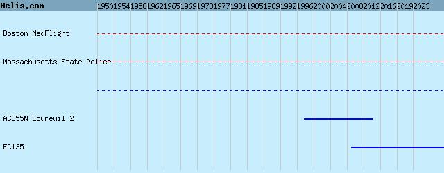
List of aircraft and events at Plymouth Municipal


DatesOrg/TypeUnit
2010-jun-13 Accident 47G-2 N47WK

2014-oct-29 EC145 N273NE

2015-apr-27 State of Massachusetts EC135T2+ N825MM
2015-sep-14 EC145 N274NE

2020-jun-15 MSP EC135T2+ N824AH

2021-oct-15 USCG HH-60J 6039

2025-oct-16 BMF H145D3 N247NE


Helicopters for sale
Accidents
Acronyms
Airshows
Future helicopters
Flying a helicopter
Helicopter stories
TV and movies

Helicopter books
Helicopter patches
Helicopter model kits


az


Download App