Satellite and aerial maps of Linz / Hörsching with nearby locations
Linz Airport, Lindenlacher Straße, Wagram, Hörsching, Bezirk Linz-Land, Upper Austria, 4061, Austria
| 48° 14' 19'' N 14° 11' 11'' E | | 5 nm SE of Linz, Linz, Oberösterreich | | ICAO: LOWL | IATA: LNZ | | Elevation: 978 feet |
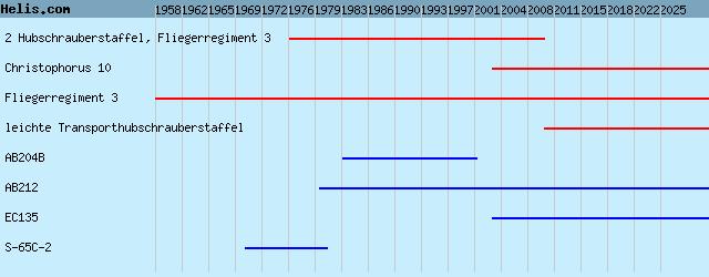
List of units at Linz / Hörsching |
04-Feb-25 - RotorSky adds a European Union Aviation Safety Agency (EASA)-qualified Flight Training Device (FTD) to be operated at Linz International Airport (LOWL) with state-of-the-art NVG capabilities #NVG
19-Jan-22 - Flight school RotorSky at Linz, Austria and German RS Flight Systems announce EASA qualification of the first F-Light Line Airbus EC135T3H (H135) Helionix Flight Simulation Training Device (FTD) #Helionix
|
|
Helicopters for sale
Accidents
Acronyms
Airshows
Future helicopters
Flying a helicopter
Helicopter stories
TV and movies
Helicopter books
Helicopter patches
Helicopter model kits

Download App
|