Satellite and aerial maps of Tatenhill with nearby locations
Tatenhill Airfield, B5234, Tatenhill, Needwood, East Staffordshire, Staffordshire, England, DE13 9PE, United Kingdom
| 52° 48' 53'' N 1° 45' 40'' W | | 4.5nm W of Burton-upon-Trent, Tatenhill, Staffordshire, England | | ICAO: EGBM | IATA: | | Elevation: 439 feet |
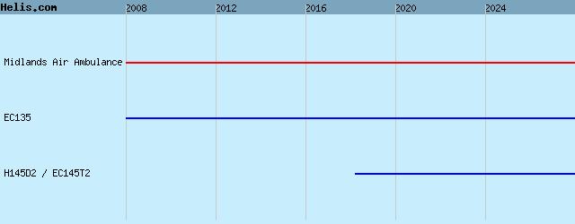
List of units at Tatenhill |
|
|
Helicopters for sale
Accidents
Acronyms
Airshows
Future helicopters
Flying a helicopter
Helicopter stories
TV and movies
Helicopter books
Helicopter patches
Helicopter model kits

Download App
|