Satellite and aerial maps of Kanoya Airbase with nearby locations
フィットネスパース, Kanoya, Kagoshima Prefecture, 893-8501, Japan
1950 to present | | 31° 21' 52'' N 130° 50' 25'' E | | 1.5nm SW of Kanoya, Kagoshima,, Kanoya, Kyushu | | ICAO: RJFY | IATA: | | Elevation: 214 feet |
List of units at Kanoya Airbase |
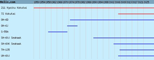
List of aircraft and events at Kanoya Airbase |
|
|
Helicopters for sale
Accidents
Acronyms
Airshows
Future helicopters
Flying a helicopter
Helicopter stories
TV and movies
Helicopter books
Helicopter patches
Helicopter model kits

Download App
|