
“Being in Florida, we are literally at ground zero for climate and weather research,” says Roni Avissar, Dean of the Rosenstiel School of Marine and Atmospheric Science at the University of Miami.
Avissar is speaking from his office just days before International Earth Day kicks off, this year with a focus on the health of the planet’s ecosystems.
“No matter what is going to happen to the climate system, it is likely that Miami is going to have significant consequences, not only due to the rising level of the ocean but Florida’s ecosystem as well, including its coral reef and fisheries. Being one of the main universities in this area dedicated to research and education, we focus on the different aspects of research that could have an impact on the climate.”
A unique research vehicle
The school contributes to the international community’s broader body of scientific knowledge that is being used to understand the planet’s ecological threats and, ultimately, look for solutions. “What we do with any observation system is a part of the answer; it’s never the full answer. A lot of incremental research is being done, spread over many years, and the information we’re collecting is being analyzed and translated into understanding the climate system,” says Avissar.
As part of its remit as a research private university, Rosenstiel’s 100 faculty members and 200 research scientists lead studies on topics ranging from marine mammal and shark conservation, to threats to fish populations like oil spills and overfishing. Of course, this only scratches the surface of the school’s work toward understanding the climate.
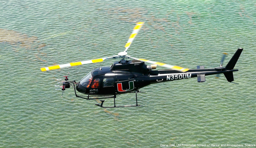
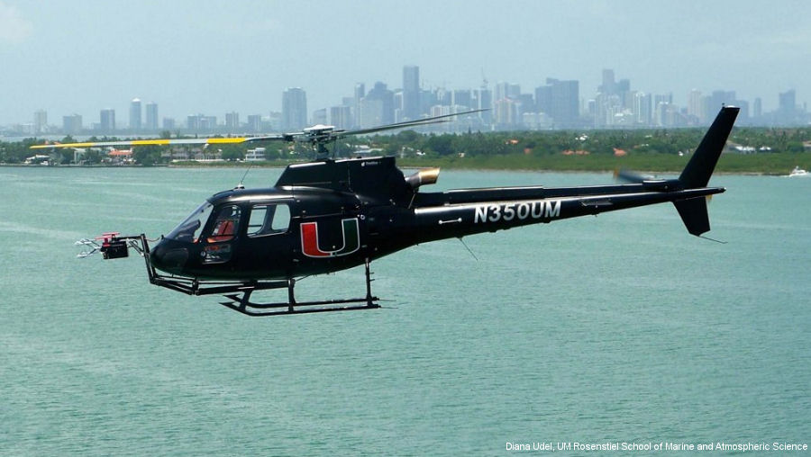
Among its research tools is an innovative flying laboratory. The HOP, or Helicopter Observation Platform, is a standard H125 helicopter kitted out with sensors, cameras, radar and computers. Its purpose: to fly one-of-a-kind missions.
One of these is doing remote sensing of the marine ecosystem. Special cameras onboard can monitor the color of the ocean, both at the surface and underneath it—observation they hope to put to use mapping coral reefs.
“We are in the process of developing methods of eliminating the disturbance the water is creating on top of the coral so we can assess and map the coral themselves,” Avissar notes. The department is still at the beginning of this research, but the hope is to eventually be able to see what is damaged or is in the process of being so and to monitor it over time.
Another area the HOP plays a part is in doing fundamental research on the exchanges of gases, dust and more in the atmosphere. The earth’s climate is affected by these interactions—by the transfer of humidity, particles, CO2, methane, etc. from surface to air.
“The interface between the Earth’s surface and the atmosphere is where the vast majority of the exchange of energy is redistributed by the climate system, so understanding what is happening very near the Earth’s surface is crucial,” says Avissar. “The helicopter is unmatched in its capability to go just a few feet above the Earth and make those observations.”
250 times a second
Such observations are made possible by sophisticated sensors that collect data at 250 times a second. The sensors help monitor the very rapid changes of temperature, moisture, or gases taking place at this boundary.
Because the exchange of energy associated with the changes is transported vertically into the atmosphere at a few centimeters per second, the HOP needs to sample the air at a small scale to capture the fundamental characteristics of this exchange.
Of course, it’s also by flying slowly (60 knots) and low that Avissar, as pilot, can gather the data needed. The HOP can fly anywhere from a few meters above the Earth to anywhere within the inner atmosphere (10 km). Its scientific payload of 1,000 lbs means it carries the equipment needed to view data in real time—a baggage compartment, for example, was converted into a computer station.
The helicopter complements other vessels, such as ocean-going research ships, taking off and landing from deck and delivering 350 nautical miles of range even at its top cruising speed.
It’s also ideal for reaching remote or risky places, like near hurricanes. That is why the HOP will likely play an initial part in the Rosenstiel School’s project of hurricane forecasting, monitoring gravity waves emitted by such tempests from some 300 kilometers away.
This work is still in its infancy – a theory to be tested – yet with time and an accumulation of data from HOP missions, it too may add to our knowledge of the planet’s changing climate.