Satellite and aerial maps of Metabaru with nearby locations
National Highway Route 34, Yoshida, Yoshinogari, Kanzaki County, Saga Prefecture, 842-0031, Japan
| 33° 19' 31.80'' N 130° 24' 50.41'' E | | Camp Metabaru, Kamimine, Metabaru, Kyushu | | ICAO: RJDM | IATA: | | Elevation: 53 feet |
List of units at Metabaru |
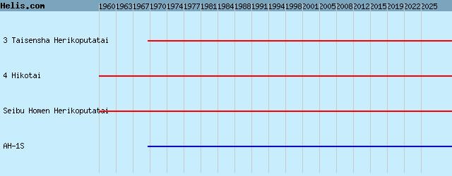
List of aircraft and events at Metabaru |
|
|
Helicopters for sale
Accidents
Acronyms
Airshows
Future helicopters
Flying a helicopter
Helicopter stories
TV and movies
Helicopter books
Helicopter patches
Helicopter model kits

Download App
|