Satellite and aerial maps of NAS Alameda / Benton with nearby locations
NAS Alameda (abandoned), Airfield Perimeter Road, Alameda, Alameda County, California, 94110, United States
1940 to 1997 | | 37° 47' 9.95'' N 122° 19' 8.40'' W | | San Francisco Bay, California, Alameda, California | | ICAO: KNGZ | IATA: NGZ | | Elevation: 14 feet |
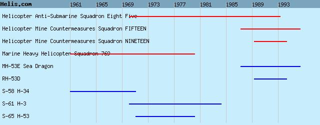
List of units at NAS Alameda / Benton |
|
|
Helicopters for sale
Accidents
Acronyms
Airshows
Future helicopters
Flying a helicopter
Helicopter stories
TV and movies
Helicopter books
Helicopter patches
Helicopter model kits

Download App
|