Satellite and aerial maps of Belem / Val de Caes with nearby locations
Val de Cans International Airport, Alameda Ametista, Cristal Ville, Val-de-Cães, Entroncamento, Belém, Região Geográfica Imediata de Belém, Região Geográfica Intermediária de Belém, Pará, North Region, 66000-000, Brazil
| Nearby locations | Km | Bearing | |
|---|
| Macapa , Amapá | 329.5 | 298 | SBMQ |
| 1° 22' 45.30'' S 48° 28' 34.68'' W | | Val de Caes, Belém, Pará | | ICAO: SBBE | IATA: BEL | | Elevation: 56 feet |
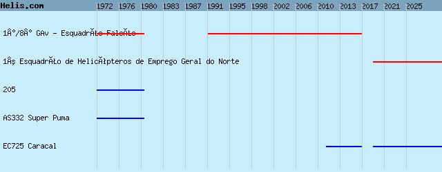
List of units at Belem / Val de Caes |
List of aircraft and events at Belem / Val de Caes |
By Date | By Serial | By Model
|
|
Helicopters for sale
Accidents
Acronyms
Airshows
Future helicopters
Flying a helicopter
Helicopter stories
TV and movies
Helicopter books
Helicopter patches
Helicopter model kits

Download App
|