Satellite and aerial maps of Oakland Intl with nearby locations
Oakland International Airport, Ron Cowan Parkway, Oakland, Alameda County, California, 94614, United States
1927 to present | | 37° 43' 17.04'' N 122° 13' 15.60'' W | | Oakland, California, Oakland, California | | ICAO: KOAK | IATA: OAK | FAA: OAK | | Elevation: 9 feet |
List of units at Oakland Intl |
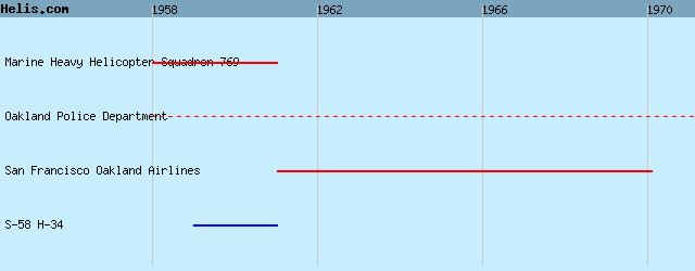
List of aircraft and events at Oakland Intl |
|
|
Helicopters for sale
Accidents
Acronyms
Airshows
Future helicopters
Flying a helicopter
Helicopter stories
TV and movies
Helicopter books
Helicopter patches
Helicopter model kits

Download App
|