Deadhorse Airport

Prudhoe Bay , Alaska

usa USA


Satellite and aerial maps of Deadhorse with nearby locations

Airport Way, Deadhorse, North Slope Borough, Alaska, 99734, United States

Nearby locationsKmBearing
Kuparuk , Alaska 45.1289PAKU
Badami , Alaska 54.5096PABP
Oliktok LRRS , Alaska 62.7302POLI
OTP Heliport , Alaska 63.1293PPNU
Oooguruk Island , Alaska 74.7297PFNU
Oooguruk Field , Alaska 74.7298


  Deadhorse


1970 to present

70° 11' 43.98'' N     148° 27' 56.84'' W
Deadhorse, Prudhoe Bay, Alaska
ICAO: PASC IATA: SCC FAA: SCC
Elevation: 67 feet


@ (optional)     Send


  List of units at Deadhorse


Years Unit
ERA Helicopters AlaskaAS350 Ecureuil, AW139, EC145,


  Deadhorse News


US Army Training Arctic Warfare in Alaska

US Army Training Arctic Warfare in Alaska

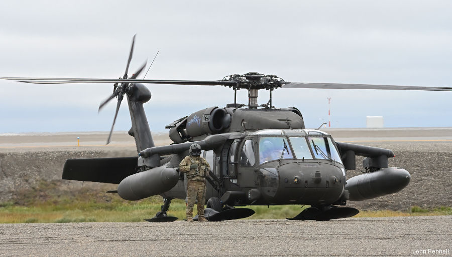
04-Sep-22 - Black Hawk and Chinook helicopters from US Army Alaska 1-52d General Support Aviation Battalion (1-52 GSAB) 16th Combat Aviation Brigade (16th CAB) prepares to support the recently reactivated 11th Airborne Division #Alaska


List of aircraft and events at Deadhorse


DatesOrg/TypeUnit
1970-may-28 206A N830JA

1988-sep-29 ERA Helicopters 212 N397EH

2010-sep-17 ERA Helicopters 212 N508EH

2014-jul-08 Evergreen Helicopters 212 N16974
2014-aug-22 412 N168EH
2014-dec-06 ERA Helicopters 212 N523EH

2015-jan-11 ERA Helicopters EC145 N186LA

2016-jan-02 ERA Helicopters EC145 N186LA

2025-oct-03 369D N138TX


Helicopters for sale
Accidents
Acronyms
Airshows
Future helicopters
Flying a helicopter
Helicopter stories
TV and movies

Helicopter books
Helicopter patches
Helicopter model kits


az


Download App