Satellite and aerial maps of Naha with nearby locations
Naha Airport, Kagamizu, Naha, Okinawa Prefecture, 901-0142, Japan
1935 to present | | 26° 11' 47.40'' N 127° 39' 0.01'' E | | 2.0nm W of Naha, Okinawa, Okinawa, Ryukyu Island | | ICAO: ROAH | IATA: OKA | | Elevation: 11 feet |
| Years | Unit | |
|---|
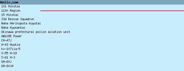
| 2010- | 15 Hikotai | UH-60JA, CH-47J, | | 1980- | Naha Herikoputa Kuyutai | CH-47J, | | 1980- | Okinawa prefectural police aviation unit | AW109E Power, | | 1960/10 | 101 Hikotai | CH-47J, | | 1955- | Naha Kyunantai | UH-60J, kv-107iia-5, | | 1955/70 |  33 RQS 33 RQS | S-61 H-3, H-43 Huskie, S-55 H-19, | | ??- | 11th Region | |
List of aircraft and events at Naha |
|
|
Helicopters for sale
Accidents
Acronyms
Airshows
Future helicopters
Flying a helicopter
Helicopter stories
TV and movies
Helicopter books
Helicopter patches
Helicopter model kits

Download App
|