Satellite and aerial maps of Eglinton / Londonderry with nearby locations
City of Derry Airport, A2, Eglinton, Causeway Coast and Glens District, Northern Ireland, BT47 3GY, United Kingdom
1941 to present | | 55° 2' 35'' N 7° 9' 35'' W | | 7nm ENE of Londonderry, Northern Ireland, Londonderry, County Londonderry, Northern Ireland | | ICAO: EGAE | IATA: LDY | | Elevation: 23 feet |
List of units at Eglinton / Londonderry |
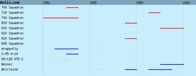
| Years | Unit | |
|---|
| 1961/63 | 819 NAS | Wessex, Whirlwind, | | 1960/61 | 719 NAS | Whirlwind, | | 1958/59 | 815 NAS | Whirlwind, Whirlwind, Whirlwind, | | 1958 | 820 NAS | Whirlwind, | | 1958/59 | 824 NAS | Whirlwind, Whirlwind, | | 1956 | 845 NAS | S-55 H-19, Whirlwind, | | 1953/54 | 706 NAS | S-55 H-19, UH-12B HTE-2, | | 1951/54 | 744 NAS | dragonfly, |
List of aircraft and events at Eglinton / Londonderry |
|
|
Helicopters for sale
Accidents
Acronyms
Airshows
Future helicopters
Flying a helicopter
Helicopter stories
TV and movies
Helicopter books
Helicopter patches
Helicopter model kits

Download App
|