Satellite and aerial maps of Rygge with nearby locations
Rygge Flystasjon, Vårliveien, Halmstad, Vårli, Rygge, Moss, Østfold, 1580, Norway
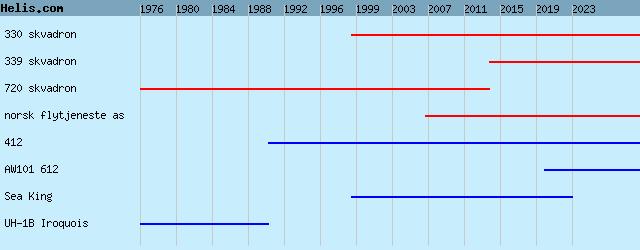
1960 to present | | 59° 22' 36'' N 10° 47' 48'' E | | Rygge -Moss, Moss, Ostfold | | ICAO: ENRY | IATA: RYG | | Elevation: 174 feet |
List of aircraft and events at Rygge |
By Date | By Serial | By Model
|
|
Helicopters for sale
Accidents
Acronyms
Airshows
Future helicopters
Flying a helicopter
Helicopter stories
TV and movies
Helicopter books
Helicopter patches
Helicopter model kits

Download App
|